Trail Walking Le Rove - Chemin des Douaniers - Le Rove - Photo
 tracegps
tracegps

User

© OpenStreetMap contributors
Length
Length
16.8 km
Max alt
Max alt
240 m
Uphill gradient
Uphill gradient
485 m
Km-Effort
Km-Effort  
23 km
Min alt
Min alt
7 m
Downhill gradient
Downhill gradient
476 m
Boucle
Boucle
Yes
Creation date :
2014-12-10 00:00:00.0
Updated on :
2014-12-10 00:00:00.0

(1 Reviews)

Walking
Walking
4h30
Difficulty : Very difficult

Scan this QR Code to open this trail in the SityTrail application

FREE GPS app for hiking

Logo SityTrail SityTrail

IGN / Geographical institutes

Download SityTrail from the App Store Download SityTrail from Google Play

Logo SityTrail SityTrail World

The world is yours!

Download SityTrail from the App Store Download SityTrail from Google Play Download SityTrail on Huawei AppGallery

About

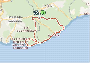
Trail Walking of 16.8 km to be discovered at Provence-Alpes-Côte d'Azur, Bouches-du-Rhône, Le Rove. This trail is proposed by tracegps.

Description

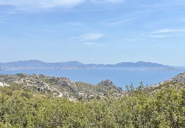
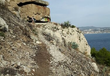
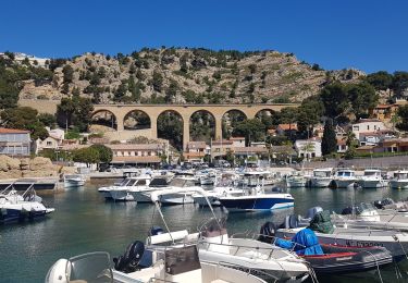
Départ du parking, près de la citerne à eau, sur le chemin de la bergerie. Le circuit offre une multitude de points de vue sur l'intérieur des terres ou sur la côte. La descente vous emmène au cap Ragnon. Vous suivez la côte par le chemin des douaniers jusqu'au port de Petit Méjean. De là, on rejoint après avoir emprunter un sentier le vallon du Pérussier jusqu'à la Plaine de Sui. Vous rejoindrez votre point de départ en empruntant le plateau du Médecin.

Elevation profile

Photos

Positioning

Country:
France
Region :
Provence-Alpes-Côte d'Azur
Department/Province :
Bouches-du-Rhône
Municipality :
Le Rove
Location:
Unknown
Start:(UTM)
681335 ; 4802800 (31T) N.

Comments

Please log in to post a review or rate the element


belle randonnée


Trails nearby

Trail Walking Le Rove - Calanque de la Vesse - Niolon la Vesse - Photo
Walking
tracegps

Walking

Medium
(1)
Le Rove, Provence-Alpes-Côte d'Azur, Bouches-du-Rhône, France
5.7 km | 8.3 km-effort
2h 15min
Yes
Trail Walking Le Rove - Côté bleue  - Photo
Walking
GUIDE
nadinebondoux

Walking

Difficult
Le Rove, Provence-Alpes-Côte d'Azur, Bouches-du-Rhône, France
13.2 km | 18.7 km-effort
4h 39min
Yes
Trail On foot Ensuès-la-Redonne - Grand Sentier de la Côte Bleue - Photo
On foot
PRO

On foot

Very difficult
Ensuès-la-Redonne, Provence-Alpes-Côte d'Azur, Bouches-du-Rhône, France
50 km | 60 km-effort
13h 34min
No
Trail On foot Le Rove - Le fort de Niolon - Photo
On foot
PRO

On foot

Easy
Le Rove, Provence-Alpes-Côte d'Azur, Bouches-du-Rhône, France
4.2 km | 6.6 km-effort
1h 29min
Yes
Trail Walking Le Rove - de Niolon à l'Erévine - Photo
Walking
GUIDE
amiral13

Walking

Easy
(1)
Le Rove, Provence-Alpes-Côte d'Azur, Bouches-du-Rhône, France
7.3 km | 11.1 km-effort
2h 47min
Yes
Trail Walking Le Rove - Cote bleue - Photo
Walking
GUIDE
nadinebondoux

Walking

Difficult
Le Rove, Provence-Alpes-Côte d'Azur, Bouches-du-Rhône, France
18.7 km | 26 km-effort
6h 48min
Yes
Trail Walking Le Rove - le Rove - Photo
Walking
GARROUSTE

Walking

Easy
(1)
Le Rove, Provence-Alpes-Côte d'Azur, Bouches-du-Rhône, France
8.7 km | 11.5 km-effort
2h 32min
Yes
Trail Walking Le Rove - de l'Establon au port de la Vesse - Photo
Walking
GUIDE
amiral13

Walking

Easy
Le Rove, Provence-Alpes-Côte d'Azur, Bouches-du-Rhône, France
9 km | 13.5 km-effort
5h 9min
Yes
Trail Walking Ensuès-la-Redonne - La Redonne - Calanques des Anthénors et de Figuières - Photo
Walking
patjobou

Walking

Medium
Ensuès-la-Redonne, Provence-Alpes-Côte d'Azur, Bouches-du-Rhône, France
4.6 km | 6.7 km-effort
1h 46min
Yes


Close
My subscriptions